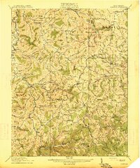
1914 Map of Crawford
USGS Topo · Published 1914About this map
Collins Settlement and the surrounding districts of Lewis and Upshur counties reveal a landscape defined by the rugged headwaters of the West Fork River and the Kanawha River. Surveyed in the early 1910s, the map documents a decentralized network of small mountain communities and one-room schoolhouses like Radabaugh School and McCutcheon School that served the rural population. The West Virginia and Pittsburg RR skirts the western edge through Roanoke, while the interior relies on older hubs like Alkires Mills and Frenchton. Distinctive topographic landmarks, such as the curiously named Devils Darning Needle and Handkerchief Knob, serve as natural waypoints between the narrow hollows. This era represents the peak of rural settlement density in these highlands, before the consolidation of industry and schools altered the local geography.
Find a feature on this map
147 named features on this map. Tap any name to fly to it.
Don’t see what you’re looking for? This feature index may not catch every label — zoom into the map to look around manually.
Map Details
Editions of this 1914 Crawford Map
3 editions found

Other maps of this area

1893 · Buckhannon
USGS Topo · 1:125,000

1893 · Sutton
USGS Topo · 1:125,000

1896 · Buckhannon
USGS Topo · 1:125,000

1897 · Buckhannon
USGS Topo · 1:125,000

1904 · Philippi
USGS Topo · 1:62,500

1904 · Weston
USGS Topo · 1:62,500

1904 · Vadis
USGS Topo · 1:62,500

1906 · Burnsville
USGS Topo · 1:62,500

1908 · Sutton
USGS Topo · 1:48,000

1910 · Sutton Special
USGS Topo · 1:62,500