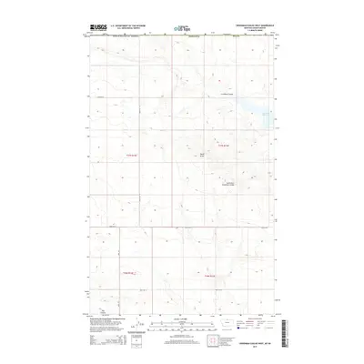
2014 Map of Creedman Coulee West
USGS Topo · Published 2014About this map
The international boundary between the United States of America and Canada defines the northern edge of this northern Hill County landscape. The terrain is characterized by a network of drainage channels, including the prominent Creedman Coulee and South Fork Greenman Coulee, which snake across the plains toward the east. This 2014 survey captures a rural landscape where water management and cattle ranching are central to land use, evidenced by the presence of Creedman Reservoir and a system of section-line access routes such as Road 415 N and Road 240 N. A distinctive high point, Signal Butte, rises above the surrounding coulees, while Dog Coulee cuts through the southwestern portion of the sheet. Remote tracks like Amos Trl provide access to the interior of these townships, reflecting the vast, open character of the Montana-Saskatchewan borderlands.
Find a feature on this map
17 named features on this map. Tap any name to fly to it.
Don’t see what you’re looking for? This feature index may not catch every label — zoom into the map to look around manually.
Map Details
Editions of this 2014 Creedman Coulee West Map
This is the sole edition of this map. No revisions or reprints were ever made.
Other maps of this area

1912 · Thibedeau Lake
USGS Topo · 1:125,000

1953 · Havre
USGS Topo · 1:250,000

1957 · Havre
USGS Topo · 1:250,000

1958 · Havre
USGS Topo · 1:250,000

1972 · Hilldale Colony
USGS Topo · 1:24,000
1972 · Lake Thibadeau SW
USGS Topo · 1:24,000
1972 · Cottonwood
USGS Topo · 1:24,000
1972 · Creedman Coulee East
USGS Topo · 1:24,000
1972 · Wild Horse Lake East
USGS Topo · 1:24,000
1972 · Creedman Coulee West
USGS Topo · 1:24,000