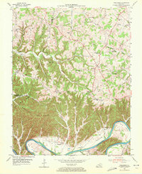
1953 Map of Creelsboro
USGS Topo · Published 1972About this map
The Cumberland River carves a deep, winding path through this region where Russell Bottom and Long Bottom provide the only significant level ground for farming. In the early 1950s, the community of Creelsboro anchored the riverbank near the mouth of Potts Branch, while small upland settlements and family-named schools like Coffey Sch and Denmark Sch dotted the ridges above. The map reveals a landscape heavily partitioned by the rugged drainage of Crocus Creek and Cabin Fork Creek, which isolated communities on high ground such as Melson Ridge. This era shows a transition in local centers, with both Olga and Old Olga noted, alongside numerous rural landmarks like Highway Mission and Grider Chapel that served the disparate valley and ridge populations.
Find a feature on this map
71 named features on this map. Tap any name to fly to it.
Don’t see what you’re looking for? This feature index may not catch every label — zoom into the map to look around manually.
Map Details
Editions of this 1953 Creelsboro Map
Other maps of this area

1953 · Amandaville
USGS Topo · 1:24,000

1953 · Montpelier
USGS Topo · 1:24,000

1953 · Burkesville
USGS Topo · 1:24,000

1953 · Wolf Creek Dam
USGS Topo · 1:24,000

1953 · Creelsboro
USGS Topo · 1:24,000

1953 · Jamestown
USGS Topo · 1:24,000

1954 · Cumberland City
USGS Topo · 1:24,000

1954 · Columbia
USGS Topo · 1:24,000

1954 · Russell Springs
USGS Topo · 1:24,000

1956 · Corbin
USGS Topo · 1:250,000