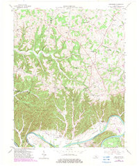
1953 Map of Creelsboro
USGS Topo · Published 1983About this map
Crocus Creek meanders through a landscape of deep valleys and prominent heights like Chestnut Flat Ridge, eventually joining the Cumberland River near the historic settlement of Creelsboro. This mid-century survey documents a rural Kentucky economy rooted in the river bottoms, where names like Wells Bottom, Long Bottom, and Coe Bottom signify fertile agricultural pockets. Transport across the water was facilitated by Winfreys Ferry, a vital link before modern bridge networks became commonplace.
Find a feature on this map
80 named features on this map. Tap any name to fly to it.
Don’t see what you’re looking for? This feature index may not catch every label — zoom into the map to look around manually.
Map Details
Editions of this 1953 Creelsboro Map
Other maps of this area

1953 · Amandaville
USGS Topo · 1:24,000

1953 · Montpelier
USGS Topo · 1:24,000

1953 · Burkesville
USGS Topo · 1:24,000

1953 · Wolf Creek Dam
USGS Topo · 1:24,000

1953 · Creelsboro
USGS Topo · 1:24,000

1953 · Jamestown
USGS Topo · 1:24,000

1954 · Cumberland City
USGS Topo · 1:24,000

1954 · Columbia
USGS Topo · 1:24,000

1954 · Russell Springs
USGS Topo · 1:24,000

1956 · Corbin
USGS Topo · 1:250,000