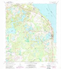
1970 Map of Crescent City
USGS Topo · Published 1989About this map
Crescent Lake dominates the eastern landscape of this 1970s Putnam County study, providing the geographic anchor for settlements like Crescent City and Lake Como. The area is defined by its complex hydrology, where numerous smaller basins such as Silver Lake, Lake Margaret, and Clear Lake are interspersed with citrus groves and wetlands. The transport network of the era is clearly visible, centered on the Seaboard Coast Line railroad which connects several communities from Pomona Park in the north down to Crescent City Station. Local landmarks like Thunderbird Airpark and the Crescent City High School reflect the mid-century infrastructure of the region. Genealogists will find particular value in the documentation of several local burial grounds, including Eden Cem, Greenwood Cem, and the Pomona-Lake Como Cem.
Find a feature on this map
32 named features on this map. Tap any name to fly to it.
Don’t see what you’re looking for? This feature index may not catch every label — zoom into the map to look around manually.
Map Details
Editions of this 1970 Crescent City Map
3 editions found

Other maps of this area

1912 · Palatka
USGS Topo · 1:48,000

1915 · Palatka
USGS Topo · 1:62,500

1937 · Dinner Island
USGS Topo · 1:48,000

1943 · Dinner Island
USGS Topo · 1:62,500

1944 · Dinner Island
USGS Topo · 1:62,500

1954 · Daytona Beach
USGS Topo · 1:250,000

1958 · Daytona Beach
USGS Topo · 1:250,000

1964 · Daytona Beach
USGS Topo · 1:250,000
1968 · Satsuma
USGS Topo · 1:24,000
1968 · San Mateo
USGS Topo · 1:24,000