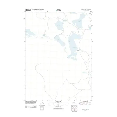
2011 Map of Crescent Lake
USGS Topo · Published 2011About this map
Crescent Lake and its surrounding wetlands dominate this Garden County landscape, illustrating a complex hydrologic network in Nebraska's Sandhills. This 2011 survey details a region defined by numerous large water bodies, including Island Lake, Blue Lake, and Hackberry Lake, which are interconnected by drainages like Jones Run and Blue Creek. The presence of the Crescent Lake Dam indicates water management efforts in this lacustrine environment, while landmarks such as Old Lady Beam Hill provide distinct topographic relief against the low-lying basin. The map records the local infrastructure of the era, centered on Road 181 and the isolated settlement at Eldred Camp, offering a precise view of the region's geography before more recent shifts in climate and land use impacted these fragile Nebraska water systems.
Find a feature on this map
15 named features on this map. Tap any name to fly to it.
Don’t see what you’re looking for? This feature index may not catch every label — zoom into the map to look around manually.
Map Details
Editions of this 2011 Crescent Lake Map
This is the sole edition of this map. No revisions or reprints were ever made.
Other maps of this area

1896 · Browns Creek
USGS Topo · 1:125,000

1899 · Browns Creek
USGS Topo · 1:125,000

1949 · Mumper
USGS Topo · 1:62,500

1950 · Crescent Lake
USGS Topo · 1:62,500

1950 · Storm Lake
USGS Topo · 1:62,500

1954 · Scottsbluff
USGS Topo · 1:250,000

1958 · Scottsbluff
USGS Topo · 1:250,000

1971 · Richardson Lake
USGS Topo · 1:24,000
1971 · Buske Ranch
USGS Topo · 1:24,000

1985 · Crescent Lake
USGS Topo · 1:100,000