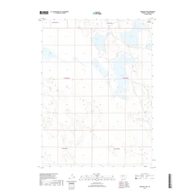
2017 Map of Crescent Lake
USGS Topo · Published 2017About this map
Crescent Lake dominates this portion of the Nebraska Sandhills, serving as the namesake for a landscape defined by its high-plains wetlands. The intricate shoreline of Island Lake and the sheltered Mallard Arm of the primary lake illustrate the complex hydrology of this Garden County region. The terrain is marked by distinctive elevations like Old Lady Beam Hill, which rises above the surrounding basin. This 2017 survey reveals an environment where water and wind-shaped landforms dictate the character of the country, with smaller bodies such as Hackberry Lake, Blue Lake, and Swan Lake scattered across the township lines. Remote tracks like RD 181 provide the primary access through this sparsely populated territory, while drainage features like Jones Run and Blue Cr connect the disparate basins.
Find a feature on this map
19 named features on this map. Tap any name to fly to it.
Don’t see what you’re looking for? This feature index may not catch every label — zoom into the map to look around manually.
Map Details
Editions of this 2017 Crescent Lake Map
This is the sole edition of this map. No revisions or reprints were ever made.
Other maps of this area

1896 · Browns Creek
USGS Topo · 1:125,000

1899 · Browns Creek
USGS Topo · 1:125,000

1949 · Mumper
USGS Topo · 1:62,500

1950 · Crescent Lake
USGS Topo · 1:62,500

1950 · Storm Lake
USGS Topo · 1:62,500

1954 · Scottsbluff
USGS Topo · 1:250,000

1958 · Scottsbluff
USGS Topo · 1:250,000

1971 · Richardson Lake
USGS Topo · 1:24,000
1971 · Buske Ranch
USGS Topo · 1:24,000

1985 · Crescent Lake
USGS Topo · 1:100,000