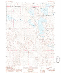
1986 Map of Crescent Lake
USGS Topo · Published 1986About this map
The Crescent Lake National Wildlife Refuge dominates this mid-1980s topographic study, preserving a complex of alkaline lakes and sandhills in Garden County. The landscape is defined by the hydrologic network of Crescent Lake, Hackberry Lake, and Island Lake, which together form a critical sanctuary for migratory birds. To the west, Swan Lake and Blue Lake sit among the rolling dunes, with Jones Run and Blue Creek providing the primary drainage for the basin.
Find a feature on this map
21 named features on this map. Tap any name to fly to it.
Don’t see what you’re looking for? This feature index may not catch every label — zoom into the map to look around manually.
Map Details
Editions of this 1986 Crescent Lake Map
This is the sole edition of this map. No revisions or reprints were ever made.
Other maps of this area

1896 · Browns Creek
USGS Topo · 1:125,000

1899 · Browns Creek
USGS Topo · 1:125,000

1949 · Mumper
USGS Topo · 1:62,500

1950 · Crescent Lake
USGS Topo · 1:62,500

1950 · Storm Lake
USGS Topo · 1:62,500

1954 · Scottsbluff
USGS Topo · 1:250,000

1958 · Scottsbluff
USGS Topo · 1:250,000

1971 · Richardson Lake
USGS Topo · 1:24,000
1971 · Buske Ranch
USGS Topo · 1:24,000

1985 · Crescent Lake
USGS Topo · 1:100,000