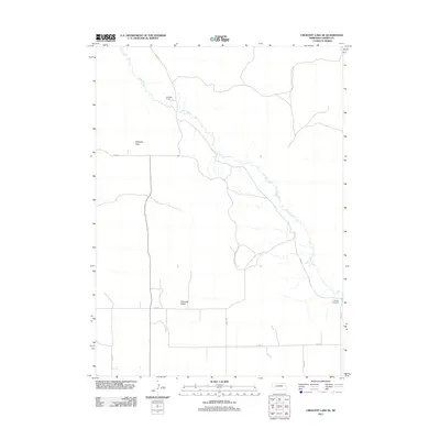
2011 Map of Crescent Lake SE
USGS Topo · Published 2011About this map
Blue Creek winds through the heart of this Garden County landscape, cutting a meandering path southeast toward the Platte River system. This 2011 survey captures a sparsely populated portion of the Nebraska Sandhills where the topography transitions from the high ground of Dogtown Flats into the broad depression of Antelope Valley. The layout of the land is defined by a rigid grid of rural routes, including Road 82 and Road 74, which serve the isolated agricultural operations of the region. A significant genealogical and local landmark, the Kingery Cemetery, sits near the eastern edge of the quadrangle, while the Richstein Ranch anchors the northern reaches of the creek. This map preserves the contemporary footprint of ranching life and land management in a region where the natural drainage of the creek remains the primary geographic feature.
Find a feature on this map
13 named features on this map. Tap any name to fly to it.
Don’t see what you’re looking for? This feature index may not catch every label — zoom into the map to look around manually.
Map Details
Editions of this 2011 Crescent Lake SE Map
This is the sole edition of this map. No revisions or reprints were ever made.
Other maps of this area

1900 · Chappell
USGS Topo · 1:125,000

1949 · Rackett
USGS Topo · 1:62,500

1950 · Crescent Lake
USGS Topo · 1:62,500

1951 · Rackett
USGS Topo · 1:62,500

1954 · Scottsbluff
USGS Topo · 1:250,000

1958 · Scottsbluff
USGS Topo · 1:250,000
1971 · Twin Buttes
USGS Topo · 1:24,000

1971 · Coumbe Bluff
USGS Topo · 1:24,000
1971 · Oshkosh
USGS Topo · 1:24,000
1985 · Chappell
USGS Topo · 1:100,000