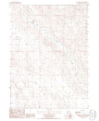
1986 Map of Crescent Lake SE
USGS Topo · Published 1986About this map
Richstein Ranch anchors this portion of the Nebraska Sandhills, a landscape defined by the winding course of Blue Creek. The terrain transitions from the broad level of Dogtown Flats in the northwest to the more defined drainage of Antelope Valley in the south. This 1980s-era documentation reflects a working cattle-ranching environment, where isolated infrastructure like scattered wells and specialized Feed Lots are essential for supporting livestock in this semi-arid region. The presence of a Spring along the creek bank underscores the vital role of natural water sources in an otherwise dry prairie. The map provides a clear look at the large-scale land management patterns and section lines characteristic of Garden County rangeland during the late twentieth century.
Find a feature on this map
8 named features on this map. Tap any name to fly to it.
Don’t see what you’re looking for? This feature index may not catch every label — zoom into the map to look around manually.
Map Details
Editions of this 1986 Crescent Lake SE Map
This is the sole edition of this map. No revisions or reprints were ever made.
Other maps of this area

1900 · Chappell
USGS Topo · 1:125,000

1949 · Rackett
USGS Topo · 1:62,500

1950 · Crescent Lake
USGS Topo · 1:62,500

1951 · Rackett
USGS Topo · 1:62,500

1954 · Scottsbluff
USGS Topo · 1:250,000

1958 · Scottsbluff
USGS Topo · 1:250,000
1971 · Twin Buttes
USGS Topo · 1:24,000

1971 · Coumbe Bluff
USGS Topo · 1:24,000
1971 · Oshkosh
USGS Topo · 1:24,000
1985 · Chappell
USGS Topo · 1:100,000