1980 Map of Crescent Mills
USGS Topo · Published 1980About this map
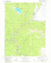
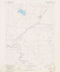
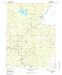
The Western Pacific Railroad snakes through this high-altitude landscape, following the dramatic canyons of Spanish Creek and the East Branch North Fork Feather River. This rail engineering is particularly evident near Keddie, where the famous Wye is situated amidst a series of numbered tunnels, including Tunnel No 30 and Tunnel No 31. The industrial legacy of the region is reflected in numerous mining sites such as the Arcadia Mine, Standart Mine, and the Cherokee Mine (Site) located north of Crescent Mills. The map also documents the hydrology of the area, featuring the Round Valley Reservoir and the Round Valley (Site), alongside smaller settlements like Indian Falls and Paxton. Much of the eastern terrain is protected within the Plumas National Forest and the State Game Refuge, rising toward the heights of Mount Hough and Arlington Heights.
Find a feature on this map
55 named features on this map. Tap any name to fly to it.
Don’t see what you’re looking for? This feature index may not catch every label — zoom into the map to look around manually.
Map Details
Editions of this 1980 Crescent Mills Map
3 editions found
Other maps of this area

1886 · Honey Lake
USGS Topo · 1:250,000

1886 · Lassen Peak
USGS Topo · 1:250,000

1888 · Bidwell Bar
USGS Topo · 1:125,000

1891 · Bidwell Bar
USGS Topo · 1:125,000

1891 · Downieville
USGS Topo · 1:125,000

1891 · Honey Lake
USGS Topo · 1:250,000

1892 · Lassen Peak
USGS Topo · 1:250,000

1893 · Bidwell Bar
USGS Topo · 1:125,000

1893 · Honey Lake
USGS Topo · 1:250,000

1893 · Downieville
USGS Topo · 1:125,000