1980 Map of Crescent Mills
USGS Topo · Published 1986About this map
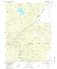
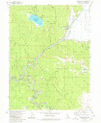
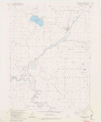
The Western Pacific Railroad snakes through this high-altitude landscape of Plumas County, defining the corridor between Crescent Mills and Keddie. The rail line is a marvel of engineering on this sheet, featuring a series of tunnels ranging from Tunnel No 26 to Tunnel No 33 as it follows the steep banks of Spanish Creek and the Feather River. Historically significant mining sites like the Arcadia Mine and Standart Mine overlook North Canyon, while the Cherokee Mine (Site) sits near the Round Valley Reservoir. The map captures the meeting of industrial infrastructure and mountain terrain, from the Gaging Station and Arlington Bridge along Indian Creek to the recreational Golf Course and Round Valley Campground. This area within the Plumas National Forest shows a concentrated pattern of settlement and utility development along the narrow valley floors, preserving the layout of mountain communities and their connection to the timber and mining industries of the Sierra Nevada.
Find a feature on this map
62 named features on this map. Tap any name to fly to it.
Don’t see what you’re looking for? This feature index may not catch every label — zoom into the map to look around manually.
Map Details
Editions of this 1980 Crescent Mills Map
3 editions found
Other maps of this area

1886 · Honey Lake
USGS Topo · 1:250,000

1886 · Lassen Peak
USGS Topo · 1:250,000

1888 · Bidwell Bar
USGS Topo · 1:125,000

1891 · Bidwell Bar
USGS Topo · 1:125,000

1891 · Downieville
USGS Topo · 1:125,000

1891 · Honey Lake
USGS Topo · 1:250,000

1892 · Lassen Peak
USGS Topo · 1:250,000

1893 · Bidwell Bar
USGS Topo · 1:125,000

1893 · Honey Lake
USGS Topo · 1:250,000

1893 · Downieville
USGS Topo · 1:125,000