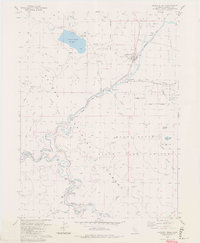
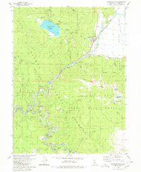
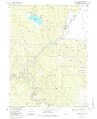
1980 Map of Crescent Mills
USGS Topo · Published 1980About this map
Mining and rail infrastructure define this portion of the Plumas National Forest in the late 20th century. The settlement of Crescent Mills sits at the edge of Indian Valley, serving as a central point between high mountain ridges and the deep canyons of the East Fork Feather River. The industrial history of the region is evident in the numerous legacy sites, including the Arcadia Mine, Standart Mine, and the Monitor Mine. Evidence of earlier habitation remains at Round Valley, now overshadowed by the Round Valley Reservoir.
Find a feature on this map
60 named features on this map. Tap any name to fly to it.
Don’t see what you’re looking for? This feature index may not catch every label — zoom into the map to look around manually.
Map Details
Editions of this 1980 Crescent Mills Map
3 editions found
Other maps of this area

1886 · Honey Lake
USGS Topo · 1:250,000

1886 · Lassen Peak
USGS Topo · 1:250,000

1888 · Bidwell Bar
USGS Topo · 1:125,000

1891 · Bidwell Bar
USGS Topo · 1:125,000

1891 · Downieville
USGS Topo · 1:125,000

1891 · Honey Lake
USGS Topo · 1:250,000

1892 · Lassen Peak
USGS Topo · 1:250,000

1893 · Bidwell Bar
USGS Topo · 1:125,000

1893 · Honey Lake
USGS Topo · 1:250,000

1893 · Downieville
USGS Topo · 1:125,000