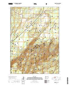
2020 Map of Crescent NE
USGS Topo · Published 2020About this map
Walker Rim serves as the dominant geographical feature of this high-altitude landscape, defining the transition between two of Oregon's major timber and wilderness regions. This portion of Klamath County is bisected by the boundary between the Deschutes National Forest to the north and the Winema National Forest to the south. The terrain is characterized by the stark escarpment of the rim, which rises sharply from the lower elevations in the northern sections. Grounded in the t25s r9e and t24s r10e township and range system, the map details a remote forested area where public land management and natural topography intersect. The lack of named settlements emphasizes the character of this territory as a working forest and wildlife corridor.
Find a feature on this map
7 named features on this map. Tap any name to fly to it.
Don’t see what you’re looking for? This feature index may not catch every label — zoom into the map to look around manually.
Map Details
Editions of this 2020 Crescent NE Map
This is the sole edition of this map. No revisions or reprints were ever made.
Other maps of this area

1930 · Maiden Peak
USGS Topo · 1:125,000

1931 · Newberry Crater
USGS Topo · 1:125,000

1934 · Maiden Peak
USGS Topo · 1:125,000

1935 · Chemult
USGS Topo · 1:96,000

1935 · Newberry Crater
USGS Topo · 1:125,000

1941 · Chemult
USGS Topo · 1:125,000

1955 · Crescent
USGS Topo · 1:250,000

1957 · Crescent
USGS Topo · 1:250,000

1958 · Crescent
USGS Topo · 1:250,000

1963 · Masten Butte
USGS Topo · 1:24,000