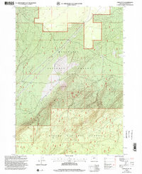
1999 Map of Crescent NE
USGS Topo · Published 2002About this map
The high-altitude terrain of Walker Mountain dominates this Klamath County landscape, which sits at a significant jurisdictional junction. The map documents the boundary where the Deschutes National Forest meets the Winema National Forest, illustrating a heavily forested and topographically complex region of the Oregon Cascades. A critical piece of local infrastructure is found at Fremont Siding, a named railroad point along the tracks that cut through the mountain's lower slopes. The topography here is defined by sharp elevation changes and forest management lines, captured during the USDA Forest Service's 1999 revision of earlier 1960s surveys. For historians and land researchers, the map provides a clear record of forest access roads and the relationship between the rail corridor and the surrounding timberlands.
Find a feature on this map
5 named features on this map. Tap any name to fly to it.
Don’t see what you’re looking for? This feature index may not catch every label — zoom into the map to look around manually.
Map Details
Editions of this 1999 Crescent NE Map
This is the sole edition of this map. No revisions or reprints were ever made.
Other maps of this area

1930 · Maiden Peak
USGS Topo · 1:125,000

1931 · Newberry Crater
USGS Topo · 1:125,000

1934 · Maiden Peak
USGS Topo · 1:125,000

1935 · Chemult
USGS Topo · 1:96,000

1935 · Newberry Crater
USGS Topo · 1:125,000

1941 · Chemult
USGS Topo · 1:125,000

1955 · Crescent
USGS Topo · 1:250,000

1957 · Crescent
USGS Topo · 1:250,000

1958 · Crescent
USGS Topo · 1:250,000

1963 · Masten Butte
USGS Topo · 1:24,000