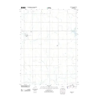
2011 Map of Creston
USGS Topo · Published 2011About this map
Creston occupies the western edge of this agricultural landscape in Platte County, where the village is centered around the Creston Post Office. This part of Nebraska is defined by a grid of rural routes like Monastery Rd and 822nd Rd that partition the land between several winding waterways. Genealogists will find two distinct burial sites preserved on this sheet: the Fairview Cemetery north of town and the more isolated Creston Pioneer Cemetery further east. The drainage pattern is dictated by Meridian Creek and the West Fork Maple Creek, with the headwaters of Loseke Creek carving through the southern sections. This survey provides a clear view of the rural township structure and small-town Nebraska life during the early twenty-first century.
Find a feature on this map
17 named features on this map. Tap any name to fly to it.
Don’t see what you’re looking for? This feature index may not catch every label — zoom into the map to look around manually.
Map Details
Editions of this 2011 Creston Map
This is the sole edition of this map. No revisions or reprints were ever made.
Other maps of this area

1955 · Fremont
USGS Topo · 1:250,000

1957 · Fremont
USGS Topo · 1:250,000

1958 · Fremont
USGS Topo · 1:250,000

1963 · Madison
USGS Topo · 1:24,000

1963 · Madison SE
USGS Topo · 1:24,000

1966 · Clarkson SW
USGS Topo · 1:24,000

1966 · Platte Center
USGS Topo · 1:24,000

1966 · Humphrey SE
USGS Topo · 1:24,000

1966 · Creston
USGS Topo · 1:24,000
1966 · Stanton SW
USGS Topo · 1:24,000