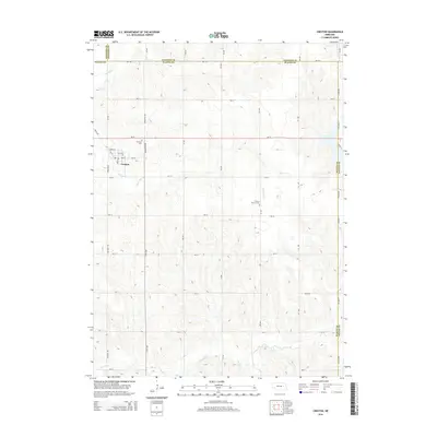
2014 Map of Creston
USGS Topo · Published 2014About this map
Creston is the primary settlement on this Nebraska landscape, situated near the headwaters of several drainages that define the local topography. The village layout is clearly visible, featuring a network of streets including Cherry St, Elm St, and Pine St along the railroad corridor. Outside the town center, the land is marked by a strict section-line road grid that crosses the rolling divides between Meridian Cr, Loseke Cr, and the W Fork Maple Cr. Genealogy researchers will find specific interest in Fairview Cem located north of the village and the Creston Pioneer Cem situated further east, providing a clear record of local family history and settlement patterns. The map also delineates the convergence of several county boundaries, including the borders of Madison, Stanton, Platte, and Colfax counties.
Find a feature on this map
25 named features on this map. Tap any name to fly to it.
Don’t see what you’re looking for? This feature index may not catch every label — zoom into the map to look around manually.
Map Details
Editions of this 2014 Creston Map
This is the sole edition of this map. No revisions or reprints were ever made.
Other maps of this area

1955 · Fremont
USGS Topo · 1:250,000

1957 · Fremont
USGS Topo · 1:250,000

1958 · Fremont
USGS Topo · 1:250,000

1963 · Madison
USGS Topo · 1:24,000

1963 · Madison SE
USGS Topo · 1:24,000

1966 · Clarkson SW
USGS Topo · 1:24,000

1966 · Platte Center
USGS Topo · 1:24,000

1966 · Humphrey SE
USGS Topo · 1:24,000

1966 · Creston
USGS Topo · 1:24,000
1966 · Stanton SW
USGS Topo · 1:24,000