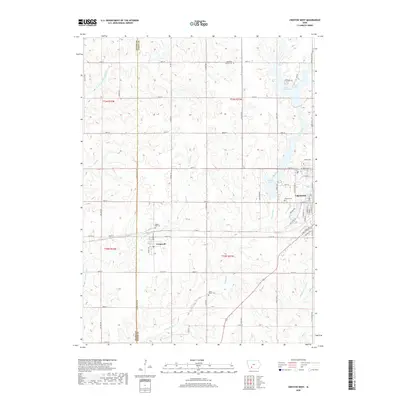
2018 Map of Creston West
USGS Topo · Published 2018About this map
The boundary between Adams Co and Union Co divides this rural landscape, defined by the headwaters of the Platte River system and the western residential expansion of Creston. The terrain is marked by the winding courses of the Platte River, the W Platte River, and the Middle Platte River, which drain the agricultural uplands. Significant water resources include Green Valley Lake in the northeast and Summit Lake, which borders the Creston city limits.
Find a feature on this map
62 named features on this map. Tap any name to fly to it.
Don’t see what you’re looking for? This feature index may not catch every label — zoom into the map to look around manually.
Map Details
Editions of this 2018 Creston West Map
This is the sole edition of this map. No revisions or reprints were ever made.
Other maps of this area

1954 · Omaha
USGS Topo · 1:250,000

1955 · Nebraska City
USGS Topo · 1:250,000

1957 · Nebraska City
USGS Topo · 1:250,000

1957 · Omaha
USGS Topo · 1:250,000

1958 · Omaha
USGS Topo · 1:250,000

1958 · Nebraska City
USGS Topo · 1:250,000

1980 · Lenox
USGS Topo · 1:24,000

1980 · Nevinville
USGS Topo · 1:24,000

1980 · Creston East
USGS Topo · 1:24,000
1980 · Prescott
USGS Topo · 1:24,000