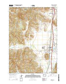
2014 Map of Creswell
USGS Topo · Published 2014About this map
Spencer Butte and Creswell Butte anchor the topography of this corridor south of Eugene, where the Willamette Valley floor meets the rising timbered hills. The settlement of Creswell serves as the primary hub, situated along the Coast Fork Willamette River and the industrial infrastructure of the Rummel Millrace. Several smaller communities and rural localities like Goshen and Lynx Hollow are documented, alongside aviation activity at Hobby Field Airport. Genealogists will find a significant concentration of burial sites, including the Goshen Grange 561 Cem, Moxley Cem, and the private Jackson Family Cem. The complex drainage patterns of the area are traced through Camas Swale Cr and numerous reservoirs like Fadeley Reservoir and Pembrook Reservoir, reflecting the region's managed water resources.
Find a feature on this map
113 named features on this map. Tap any name to fly to it.
Don’t see what you’re looking for? This feature index may not catch every label — zoom into the map to look around manually.
Map Details
Editions of this 2014 Creswell Map
This is the sole edition of this map. No revisions or reprints were ever made.
Other maps of this area

1910 · Eugene
USGS Topo · 1:62,500

1921 · Cottage Grove
USGS Topo · 1:62,500

1935 · Lowell
USGS Topo · 1:96,000

1940 · Eugene
USGS Topo · 1:62,500

1942 · Lowell
USGS Topo · 1:125,000

1946 · Eugene
USGS Topo · 1:62,500

1949 · Eugene
USGS Topo · 1:62,500

1950 · Marcola
USGS Topo · 1:62,500

1952 · Marcola
USGS Topo · 1:62,500

1953 · Salem
USGS Topo · 1:250,000