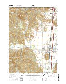
2017 Map of Creswell
USGS Topo · Published 2017About this map
Spencer Butte and the Hideaway Hills dominate the northern landscape of this survey, marking the transition from the Eugene metropolitan edge toward the rural valley floors of Lane County. The settlement of Creswell serves as the southern anchor, defined by its traditional grid and proximity to Hobby Field. The land use here reflects a long history of water management and agriculture, evidenced by the Tunnel Millrace and the winding course of the Coast Fork Willamette River. Genealogists will find significant value in the documentation of local burial sites, including the Goshen Grange 561 Cem and the Jackson Family Cem. The complex drainage patterns of Camas Swale Cr and numerous small reservoirs like Fadeley Reservoir illustrate how the natural topography has been adapted for local industry and residential growth.
Find a feature on this map
109 named features on this map. Tap any name to fly to it.
Don’t see what you’re looking for? This feature index may not catch every label — zoom into the map to look around manually.
Map Details
Editions of this 2017 Creswell Map
This is the sole edition of this map. No revisions or reprints were ever made.
Other maps of this area

1910 · Eugene
USGS Topo · 1:62,500

1921 · Cottage Grove
USGS Topo · 1:62,500

1935 · Lowell
USGS Topo · 1:96,000

1940 · Eugene
USGS Topo · 1:62,500

1942 · Lowell
USGS Topo · 1:125,000

1946 · Eugene
USGS Topo · 1:62,500

1949 · Eugene
USGS Topo · 1:62,500

1950 · Marcola
USGS Topo · 1:62,500

1952 · Marcola
USGS Topo · 1:62,500

1953 · Salem
USGS Topo · 1:250,000