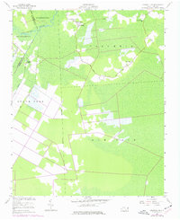
1954 Map of Creswell SE
USGS Topo · Published 1977About this map
The Scuppernong River snakes through the low-lying terrain of this coastal North Carolina landscape, defining the boundary between Washington and Tyrrell counties. This 1954 survey, with updates from the 1970s, reveals a rural region heavily influenced by drainage and land reclamation, evidenced by the prominent Old Canal and the strictly linear paths of Thirty-Foot and Bee Tree roads. Scattered congregations anchor the small communities here, including Holly Grove Ch, Cross Landing Ch, and Woodleys Chapel in the west, while Cabin Swamp Ch serves the eastern reaches near New Lands. The presence of Ballast Bank near the river suggests a history of maritime navigation and early trade. The map illustrates a transitional period for areas like Gum Neck and South Fork, where traditional swampy terrain meets modern agricultural drainage efforts.
Find a feature on this map
21 named features on this map. Tap any name to fly to it.
Don’t see what you’re looking for? This feature index may not catch every label — zoom into the map to look around manually.
Map Details
Editions of this 1954 Creswell SE Map
2 editions found
Other maps of this area

1943 · Columbia
USGS Topo · 1:125,000

1953 · Columbia East
USGS Topo · 1:24,000

1953 · Scotia
USGS Topo · 1:24,000

1953 · Columbia West
USGS Topo · 1:24,000

1953 · Fairfield NW
USGS Topo · 1:24,000

1953 · Rocky Mount
USGS Topo · 1:250,000

1954 · Rocky Mount
USGS Topo · 1:250,000
1954 · Creswell
USGS Topo · 1:24,000
1954 · Creswell SE
USGS Topo · 1:24,000
1954 · New Lake
USGS Topo · 1:24,000