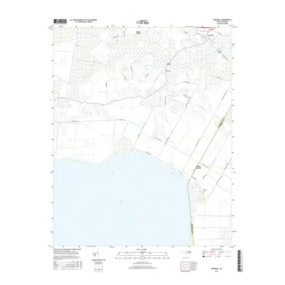
2016 Map of Creswell
USGS Topo · Published 2016About this map
Phelps Lake dominates the southern landscape of this 2016 survey, where the low-lying coastal plains of the North Carolina tidewater are defined by an extensive network of drainage infrastructure. The town of Creswell serves as the primary northern settlement, situated near the winding Scuppernong River and historical crossings like Spruills Bridge. The inland terrain between the river and the lake is heavily managed through a series of engineered waterways, including the Western Canal, Thirty-Foot Canal, and Moccasin Canal, which reflect a long-standing tradition of agricultural land reclamation in this region. This environment supports smaller crossroads communities such as Mount Tabor, Cherry, and Galilee Mission. Genealogists and local historians will find value in the placement of the Pettigrew Cem located near the lake shore, as well as several family-named roads like Gus Town Rd and Tom Pepper Rd that provide clues to local land ownership and lineage.
Find a feature on this map
46 named features on this map. Tap any name to fly to it.
Don’t see what you’re looking for? This feature index may not catch every label — zoom into the map to look around manually.
Map Details
Editions of this 2016 Creswell Map
This is the sole edition of this map. No revisions or reprints were ever made.
Other maps of this area

1914 · Belhaven
USGS Topo · 1:48,000

1916 · Belhaven
USGS Topo · 1:62,500

1943 · Columbia
USGS Topo · 1:125,000

1943 · Plymouth
USGS Topo · 1:125,000

1953 · Columbia West
USGS Topo · 1:24,000

1953 · Rocky Mount
USGS Topo · 1:250,000

1954 · Rocky Mount
USGS Topo · 1:250,000

1954 · Roper North
USGS Topo · 1:24,000

1954 · Roper South
USGS Topo · 1:24,000
1954 · Creswell
USGS Topo · 1:24,000