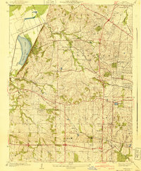
1940 Map of Creve Coeur
USGS Topo · Published 1940About this map
Creve Coeur Lake and its surrounding wetlands anchor the western edge of this suburbanizing landscape on the outskirts of St. Louis. During the 1930s, the area transitioned from agricultural use into a region of organized country clubs and educational institutions. The map reveals a high concentration of recreational and private spaces, such as the Log Cabin Country Club and Meadowbrook Country Club, alongside established centers like Chaminade College.
Find a feature on this map
57 named features on this map. Tap any name to fly to it.
Don’t see what you’re looking for? This feature index may not catch every label — zoom into the map to look around manually.
Map Details
Editions of this 1940 Creve Coeur Map
3 editions found
Other maps of this area

1903 · O'Fallon
USGS Topo · 1:125,000

1924 · Robertson
USGS Topo · 1:24,000

1927 · St. Charles
USGS Topo · 1:62,500

1931 · Manchester SE
USGS Topo · 1:24,000

1931 · Brussels
USGS Topo · 1:62,500

1932 · Manchester NE
USGS Topo · 1:24,000

1933 · Creve Coeur
USGS Topo · 1:24,000

1933 · Jefferson Barracks
USGS Topo · 1:24,000

1933 · Clayton
USGS Topo · 1:24,000

1933 · Saint Charles
USGS Topo · 1:62,500