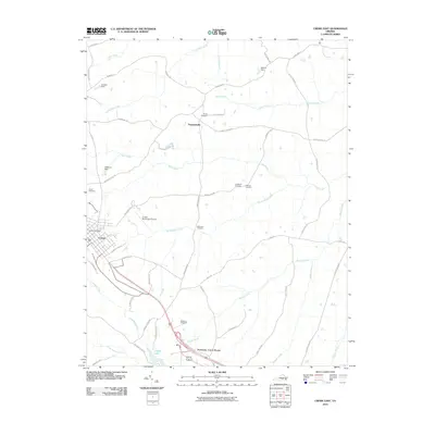
2010 Map of Crewe East
USGS Topo · Published 2010About this map
Crewe and its surrounding countryside in Nottoway County are defined by a network of creeks and small family-named landmarks. The landscape is carved by the Little Nottoway River and its numerous tributaries, including Deep Creek, Winningham Creek, and Lazaretto Creek. Local genealogy is well-preserved through several family burial grounds, such as Towler Cemetery, Strum Cemetery, and Blendon Cemetery. Transportation routes branch out from the town center, including the notable Country Club Rd and Winningham Rd, while the Crewe Municipal Airport provides a modern aerial connection to the region. The northern section near Fergusonville remains largely rural, dominated by water features like Little Creek and Calvary Branch. Several small impoundments, including Arnolds Dam and Austins Dam, illustrate the local management of the area's many waterways, while Crystal Lake offers a larger body of water near the southern boundary.
Find a feature on this map
53 named features on this map. Tap any name to fly to it.
Don’t see what you’re looking for? This feature index may not catch every label — zoom into the map to look around manually.
Map Details
Editions of this 2010 Crewe East Map
This is the sole edition of this map. No revisions or reprints were ever made.
Other maps of this area

1891 · Farmville
USGS Topo · 1:125,000

1893 · Farmville
USGS Topo · 1:125,000

1897 · Amelia
USGS Topo · 1:125,000

1943 · Amelia
USGS Topo · 1:31,680

1943 · Richmond
USGS Topo · 1:250,000

1947 · Roanoke
USGS Topo · 1:250,000

1949 · Richmond
USGS Topo · 1:250,000
1950 · Wellville
USGS Topo · 1:24,000

1958 · Jetersville
USGS Topo · 1:62,500

1958 · Crewe
USGS Topo · 1:62,500