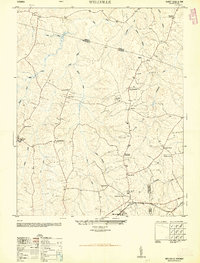
1950 Map of Wellville
USGS Topo · Published 1950About this map
Agricultural crossroads and scattered community life define this mid-century landscape where Nottoway, Amelia, and Dinwiddie Counties meet. The southern portion of the map is anchored by Wellville, situated along the Norfolk and Western railroad line. This corridor served as a vital link for the local economy, supporting nearby landmarks like the Poplar Lawn School and Poplar Lawn Church. Further north, rural social hubs are marked by the Belle Fonte Grange Hall and the King David Lodge Hall, reflecting the importance of fraternal and civic organizations in Virginia's rural Piedmont during this era.
Find a feature on this map
39 named features on this map. Tap any name to fly to it.
Don’t see what you’re looking for? This feature index may not catch every label — zoom into the map to look around manually.
Map Details
Editions of this 1950 Wellville Map
2 editions found
Other maps of this area

1891 · Farmville
USGS Topo · 1:125,000

1893 · Farmville
USGS Topo · 1:125,000

1897 · Amelia
USGS Topo · 1:125,000

1943 · Amelia
USGS Topo · 1:31,680

1943 · Goodes Bridge
USGS Topo · 1:31,680

1943 · Richmond
USGS Topo · 1:250,000

1947 · Roanoke
USGS Topo · 1:250,000

1949 · Richmond
USGS Topo · 1:250,000
1950 · Hebron
USGS Topo · 1:24,000
1950 · Darvills
USGS Topo · 1:24,000