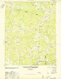
1950 Map of Wellville
USGS Topo · Published 1950About this map
The agrarian landscape of Nottoway and Amelia counties is captured here just after mid-century, defined by a network of rural hubs and family-owned mercantile stops. Commercial life centered on crossroads landmarks such as Simentons Store, Colemans Store, and Hawkes Store, which served the surrounding farming communities. The settlement pattern is rooted in local social institutions, with Belle Fonte Grange Hall and King David Lodge Hall serving as primary gathering places alongside numerous community-specific schools and churches.
Find a feature on this map
38 named features on this map. Tap any name to fly to it.
Don’t see what you’re looking for? This feature index may not catch every label — zoom into the map to look around manually.
Map Details
Editions of this 1950 Wellville Map
2 editions found
Other maps of this area

1891 · Farmville
USGS Topo · 1:125,000

1893 · Farmville
USGS Topo · 1:125,000

1897 · Amelia
USGS Topo · 1:125,000

1943 · Amelia
USGS Topo · 1:31,680

1943 · Goodes Bridge
USGS Topo · 1:31,680

1943 · Richmond
USGS Topo · 1:250,000

1947 · Roanoke
USGS Topo · 1:250,000

1949 · Richmond
USGS Topo · 1:250,000
1950 · Wellville
USGS Topo · 1:24,000
1950 · Hebron
USGS Topo · 1:24,000