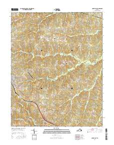
2016 Map of Crewe East
USGS Topo · Published 2016About this map
Nottoway Court House serves as a historic focal point in this portion of Southside Virginia, where the landscape is defined by the headwaters of numerous creeks and the Little Nottoway River. The town of Crewe is visible on the western edge, showing its residential street grid including E Virginia Ave and E Tennessee Ave, alongside the nearby Crewe Municipal Airport. This area is notable for its numerous family and community burial grounds, such as Blendon Cem, Lunsford Cem, and Towler Cem, which are scattered among the agricultural and wooded lands of the Piedmont. These small cemeteries, often associated with historic homesteads, provide significant touchpoints for genealogists tracing regional family lines. The topography is a complex network of stream valleys, including Deep Cr, Winningham Cr, and Woody Cr, which have historically dictated the placement of roads like Mountain Hall Rd and the settlement at Fergusonville.
Find a feature on this map
72 named features on this map. Tap any name to fly to it.
Don’t see what you’re looking for? This feature index may not catch every label — zoom into the map to look around manually.
Map Details
Editions of this 2016 Crewe East Map
This is the sole edition of this map. No revisions or reprints were ever made.
Other maps of this area

1891 · Farmville
USGS Topo · 1:125,000

1893 · Farmville
USGS Topo · 1:125,000

1897 · Amelia
USGS Topo · 1:125,000

1943 · Amelia
USGS Topo · 1:31,680

1943 · Richmond
USGS Topo · 1:250,000

1947 · Roanoke
USGS Topo · 1:250,000

1949 · Richmond
USGS Topo · 1:250,000
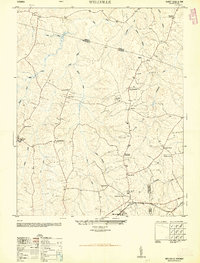
1950 · Wellville
USGS Topo · 1:24,000

1958 · Jetersville
USGS Topo · 1:62,500

1958 · Crewe
USGS Topo · 1:62,500