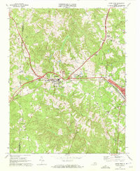
1968 Map of Crewe West
USGS Topo · Published 1972About this map
Burkeville serves as the central rail hub of this Southside Virginia landscape, where the Norfolk and Western and Southern railroads intersect. The town’s compact grid and the nearby Piedmont State Hospital illustrate the region's mid-century institutional and transportation footprint. Moving east toward Crewe, the terrain is defined by the headwaters of numerous creeks including Flat Creek and Deep Creek, which drain the undulating countryside. Local history is deeply embedded in the rural road network, connecting points like Burkes Tavern and Jennings Ordinary. The map preserves the locations of numerous community landmarks, from Wards Chapel and Hickory Grove Ch to family and church burial grounds like Downs Cem and Olive Branch Cem. This detailed survey, field-checked in the late 1960s, documents the transition from a traditional agrarian economy to one anchored by major rail corridors and public facilities.
Find a feature on this map
31 named features on this map. Tap any name to fly to it.
Don’t see what you’re looking for? This feature index may not catch every label — zoom into the map to look around manually.
Map Details
Editions of this 1968 Crewe West Map
3 editions found

Other maps of this area

1891 · Farmville
USGS Topo · 1:125,000

1893 · Farmville
USGS Topo · 1:125,000

1947 · Roanoke
USGS Topo · 1:250,000

1958 · Farmville
USGS Topo · 1:62,500

1958 · Jetersville
USGS Topo · 1:62,500

1958 · Crewe
USGS Topo · 1:62,500

1958 · Keysville
USGS Topo · 1:62,500

1959 · Roanoke
USGS Topo · 1:250,000

1963 · Roanoke
USGS Topo · 1:250,000
1968 · Deatonville
USGS Topo · 1:24,000