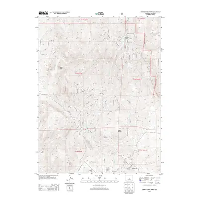
2013 Map of Cripple Creek North
USGS Topo · Published 2013About this map
Cripple Creek sits at the southern edge of this high-altitude landscape, just as it transitions toward the prominent Mount Pisgah. The terrain is defined by its mining-era legacy, with peaks like Mineral Hill, Carbonate Hill, and Rhyolite Mountain looming over a complex network of gulches and drainages. The north-south corridor of State Hwy 67 connects the main settlement with the smaller community of Midland, passing through Putney Gulch and Buchannon Gulch. This modern survey details the rugged geography of the Pike National Forest, where historical pathways like the Gold Camp Loop Rd and the Horsethief Park Trail 704 cross the eastern slopes. Genealogists will find the Mt Pisgah Cem clearly marked near the town's western outskirts, while numerous family-named landmarks and water bodies like Barnard Cr and Oil Cr provide a fine-grained view of the area's local history.
Find a feature on this map
39 named features on this map. Tap any name to fly to it.
Don’t see what you’re looking for? This feature index may not catch every label — zoom into the map to look around manually.
Map Details
Editions of this 2013 Cripple Creek North Map
This is the sole edition of this map. No revisions or reprints were ever made.
Other maps of this area

1894 · Pikes Peak
USGS Topo · 1:125,000

1901 · Pikes Peak
USGS Topo · 1:125,000

1901 · Pikes Peak
USGS Topo · 1:62,500

1942 · Cover Mtn.
USGS Topo · 1:62,500

1948 · Cover Mtn.
USGS Topo · 1:62,500

1951 · Cripple Creek South
USGS Topo · 1:24,000

1951 · Big Bull Mountain
USGS Topo · 1:24,000
1951 · Pikes Peak
USGS Topo · 1:24,000

1951 · Cripple Creek North
USGS Topo · 1:24,000

1954 · Woodland Park
USGS Topo · 1:24,000