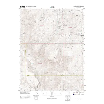
2013 Map of Cripple Creek South
USGS Topo · Published 2013About this map
Cripple Creek and its historic mining district are extensively detailed here, showing the dense network of settlements and industrial infrastructure that defined this high-altitude region. The landscape is a complex map of named peaks and industrial remnants, including Roosevelt Tunnel and Carlton Tunnel, which were critical for draining the deep gold mines of the district. Significant residential centers like Victor, Goldfield, and Elkton are situated among prominent terrain features such as Squaw Mountain and Beacon Hill.
Find a feature on this map
63 named features on this map. Tap any name to fly to it.
Don’t see what you’re looking for? This feature index may not catch every label — zoom into the map to look around manually.
Map Details
Editions of this 2013 Cripple Creek South Map
This is the sole edition of this map. No revisions or reprints were ever made.
Other maps of this area

1894 · Pikes Peak
USGS Topo · 1:125,000

1901 · Pikes Peak
USGS Topo · 1:125,000

1901 · Pikes Peak
USGS Topo · 1:62,500

1942 · Cover Mtn.
USGS Topo · 1:62,500

1948 · Cover Mtn.
USGS Topo · 1:62,500

1951 · Cripple Creek South
USGS Topo · 1:24,000

1951 · Big Bull Mountain
USGS Topo · 1:24,000
1951 · Pikes Peak
USGS Topo · 1:24,000

1951 · Cripple Creek North
USGS Topo · 1:24,000

1954 · Phantom Canyon
USGS Topo · 1:24,000