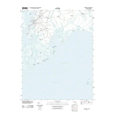
2011 Map of Crisfield
USGS Topo · Published 2011About this map
Crisfield occupies a complex amphibious landscape where the Little Annemessex River meets the expansive Pocomoke Sound. This 2011 map details a network of small, established water-side settlements such as Lawsonia, Byrdtown, and Daugherty Town, reflecting the area's deep ties to the Chesapeake Bay seafood and maritime industries. The road network, including Asbury Ave and Lafayette Rd, connects these communities across a terrain fragmented by tidal features like Island Gut and Rushy Ponds. Genealogists will find particular value in the clearly marked Mariners Cemetery and Asbury Cemetery, while the presence of the Crisfield Post Office serves as a central landmark for this coastal hub. The survey captures the intricate shoreline of Jersey Island and Cow Gap Island, illustrating the persistent relationship between these Eastern Shore towns and the shifting marshes of the sound.
Find a feature on this map
68 named features on this map. Tap any name to fly to it.
Don’t see what you’re looking for? This feature index may not catch every label — zoom into the map to look around manually.
Map Details
Editions of this 2011 Crisfield Map
This is the sole edition of this map. No revisions or reprints were ever made.
Other maps of this area

1903 · Crisfield
USGS Topo · 1:62,500

1903 · Deal Island
USGS Topo · 1:62,500

1920 · Crisfield
USGS Topo · 1:62,500

1942 · Chesconessex
USGS Topo · 1:31,680

1942 · Terrapin Sand Point
USGS Topo · 1:24,000

1942 · Great Fox Island
USGS Topo · 1:24,000

1942 · Marion
USGS Topo · 1:24,000

1942 · Kingston
USGS Topo · 1:24,000

1942 · Tangier Island
USGS Topo · 1:24,000

1942 · Saxis
USGS Topo · 1:24,000