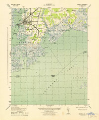
1943 Map of Crisfield
USGS Topo · Published 1943About this map
Crisfield serves as the focal point of this 1940s survey, a hub of the Chesapeake Bay seafood industry defined by its intricate shoreline and rail connection via the Pennsylvania (Crisfield Br). The map details the dense waterfront settlement around Somers Cove and Jersey, extending into smaller surrounding communities like Sackertown, Lawsonia, and Daugherty Town. Public life is anchored by landmarks such as the McCready Mem Hospital and the Armory.
Find a feature on this map
73 named features on this map. Tap any name to fly to it.
Don’t see what you’re looking for? This feature index may not catch every label — zoom into the map to look around manually.
Map Details
Editions of this 1943 Crisfield Map
This is the sole edition of this map. No revisions or reprints were ever made.
Other maps of this area

1903 · Crisfield
USGS Topo · 1:62,500

1903 · Deal Island
USGS Topo · 1:62,500

1920 · Crisfield
USGS Topo · 1:62,500

1942 · Chesconessex
USGS Topo · 1:31,680

1942 · Terrapin Sand Point
USGS Topo · 1:24,000

1942 · Great Fox Island
USGS Topo · 1:24,000

1942 · Marion
USGS Topo · 1:24,000

1942 · Kingston
USGS Topo · 1:24,000

1942 · Tangier Island
USGS Topo · 1:24,000

1942 · Saxis
USGS Topo · 1:24,000