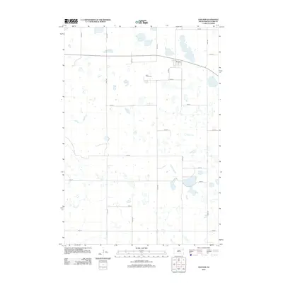
2012 Map of Crocker
USGS Topo · Published 2012About this map
The small settlement of Crocker anchors this Clark County landscape, which is defined by the high density of prairie potholes and wetlands characteristic of the region. The map captures a section of South Dakota where agriculture and natural water features exist in a complex mosaic, notably at Twin Sloughs, Mallard Slough, and Round Lake. These depressions in the terrain provide critical habitat and drainage in an area otherwise dominated by a rigid section-line road grid. For those tracing local family roots, the presence of Saint Thomas Cem south of the main townsite serves as a significant genealogical marker. The local transportation network is primarily composed of numbered avenues and streets, such as 419th Ave and 161st St, indicating the organized expansion of rural infrastructure into the early 21st century.
Find a feature on this map
21 named features on this map. Tap any name to fly to it.
Don’t see what you’re looking for? This feature index may not catch every label — zoom into the map to look around manually.
Map Details
Editions of this 2012 Crocker Map
This is the sole edition of this map. No revisions or reprints were ever made.
Other maps of this area

1953 · Milbank
USGS Topo · 1:250,000

1953 · Watertown
USGS Topo · 1:250,000

1958 · Milbank
USGS Topo · 1:250,000

1958 · Watertown
USGS Topo · 1:250,000
1958 · Crandall
USGS Topo · 1:24,000
1973 · Crocker SW
USGS Topo · 1:24,000

1973 · Lily
USGS Topo · 1:24,000

1973 · Bradley
USGS Topo · 1:24,000

1973 · Lone Tree Lake
USGS Topo · 1:24,000
1973 · Crocker
USGS Topo · 1:24,000