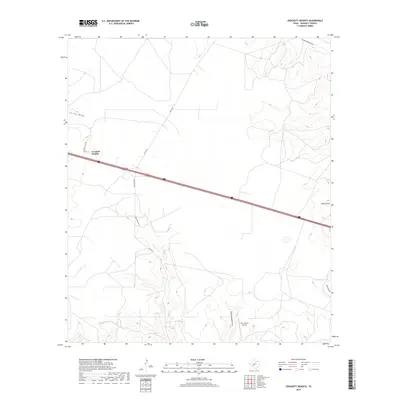
2019 Map of Crockett Heights
USGS Topo · Published 2019About this map
Crockett Heights sits atop a rise in the West Texas landscape, positioned where Crockett Hts Dr meets the transcontinental corridor of Interstate 10. This modern topographic survey illustrates the specialized ranching infrastructure that defines the region, including the remote Perry Ranch Airport to the south. The drainage patterns across this arid portion of Crockett County are clearly delineated by several significant seasonal waterways, such as Gurley Draw, Turkey Roost Draw, and Son Chapman Draw. These draws carve through the high plains, dictating the placement of rural roads like Co Rd 108 and Taylor Box Rd. The map provides a detailed view of the terrain around Nolen Draw and Willow Draw, where the subtle shifts in elevation reveal the natural catchment systems essential for life and land management in the Edwards Plateau region.
Find a feature on this map
13 named features on this map. Tap any name to fly to it.
Don’t see what you’re looking for? This feature index may not catch every label — zoom into the map to look around manually.
Map Details
Editions of this 2019 Crockett Heights Map
This is the sole edition of this map. No revisions or reprints were ever made.
Other maps of this area

1954 · Sonora
USGS Topo · 1:250,000

1958 · Sonora
USGS Topo · 1:250,000

1964 · Bailey Draw
USGS Topo · 1:24,000

1967 · Nolen Draw
USGS Topo · 1:24,000

1967 · Ozona
USGS Topo · 1:24,000

1967 · Baggett Ranch
USGS Topo · 1:24,000

1967 · Double Mill Draw SE
USGS Topo · 1:24,000

1967 · Ozona SE
USGS Topo · 1:24,000

1967 · Indio Hill
USGS Topo · 1:24,000

1967 · Crockett Heights
USGS Topo · 1:24,000