
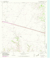
1967 Map of Crockett Heights
USGS Topo · Published 1970About this map
Crockett Heights sits atop a rise in the high plains of Crockett County, marking a localized cluster of activity in a landscape primarily defined by ranching and resource extraction. The 1966 aerial photography reveals a network of industrial and transport features, including numerous Gravel Pit sites and an Oil Well tucked near Taylor Box Draw. The presence of the Wilkins Ranch Landing Area alongside the Wilkins Ranch complex suggests the scale of remote land management in this region, where aviation and ranching operations intersect.
Find a feature on this map
19 named features on this map. Tap any name to fly to it.
Don’t see what you’re looking for? This feature index may not catch every label — zoom into the map to look around manually.
Map Details
Editions of this 1967 Crockett Heights Map
2 editions found
Other maps of this area

1954 · Sonora
USGS Topo · 1:250,000

1958 · Sonora
USGS Topo · 1:250,000

1964 · Bailey Draw
USGS Topo · 1:24,000

1967 · Nolen Draw
USGS Topo · 1:24,000

1967 · Ozona
USGS Topo · 1:24,000

1967 · Baggett Ranch
USGS Topo · 1:24,000

1967 · Double Mill Draw SE
USGS Topo · 1:24,000

1967 · Ozona SE
USGS Topo · 1:24,000

1967 · Indio Hill
USGS Topo · 1:24,000
1967 · Hospital Ranch
USGS Topo · 1:24,000