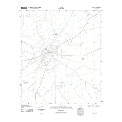
2010 Map of Crockett
USGS Topo · Published 2010About this map
Crockett serves as the central hub of this East Texas survey, where the radiating lines of State Loop 304 and numerous county roads define the transition from urban center to the surrounding timberlands and pastures. The landscape is deeply etched by a network of waterways including Hurricane Bayou, Dutch Smith Creek, and Tantabogue Creek, many of which have been harnessed to create reservoirs like Traylor Lake and Northcutt Lake. For local historians and genealogists, the map is remarkably dense with burial sites, showing the Glenwood Cemetery North Sector, Rice Cemetery, and Hunley Cemetery among others. These sites, along with landmarks like Rice Chapel and the small settlement of Druso, reveal the long-standing community structure of Houston County. Beyond the town limits, the Houston County Airport and the distinct topographic notch of Possum Pass highlight the geographic features that shaped local transportation and commerce.
Find a feature on this map
58 named features on this map. Tap any name to fly to it.
Don’t see what you’re looking for? This feature index may not catch every label — zoom into the map to look around manually.
Map Details
Editions of this 2010 Crockett Map
This is the sole edition of this map. No revisions or reprints were ever made.
Other maps of this area

1950 · Crockett
USGS Topo · 1:24,000

1950 · Crockett NE
USGS Topo · 1:24,000

1951 · Crockett
USGS Topo · 1:24,000

1951 · Grapeland
USGS Topo · 1:24,000

1951 · Berea
USGS Topo · 1:24,000

1951 · Crockett NE
USGS Topo · 1:24,000

1953 · Palestine
USGS Topo · 1:250,000

1957 · Palestine
USGS Topo · 1:250,000

1963 · Lovelady North
USGS Topo · 1:24,000
1963 · Fodice
USGS Topo · 1:24,000