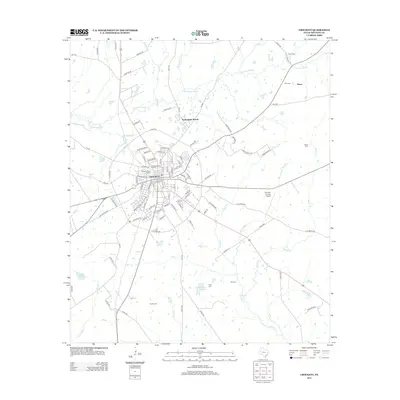
2013 Map of Crockett
USGS Topo · Published 2013About this map
The Houston County seat at Crockett dominates this 2013 survey, showcasing the city's growth around its central street grid and the E Loop 304 bypass. The landscape is defined by the winding course of Hurricane Bayou and its numerous tributaries like Sands Br and Spring Cr. For genealogists and local historians, the map is a dense record of family and community heritage, documenting sites from the large Glenwood Cem N Sector and Glenwood Cem S Sector in the city center to outlying burial grounds like Rice Cem and Smith Cem. Residential areas extend from the historic core into newer developments such as Nottingham Woods, while the rural surroundings maintain an active infrastructure evidenced by the Houston County Airport and the small settlement at Druso. The terrain is generally low-lying, punctuated by named crossings and landmarks like Possum Pass in the southeast.
Find a feature on this map
71 named features on this map. Tap any name to fly to it.
Don’t see what you’re looking for? This feature index may not catch every label — zoom into the map to look around manually.
Map Details
Editions of this 2013 Crockett Map
This is the sole edition of this map. No revisions or reprints were ever made.
Other maps of this area

1950 · Crockett
USGS Topo · 1:24,000

1950 · Crockett NE
USGS Topo · 1:24,000

1951 · Crockett
USGS Topo · 1:24,000

1951 · Grapeland
USGS Topo · 1:24,000

1951 · Berea
USGS Topo · 1:24,000

1951 · Crockett NE
USGS Topo · 1:24,000

1953 · Palestine
USGS Topo · 1:250,000

1957 · Palestine
USGS Topo · 1:250,000

1963 · Lovelady North
USGS Topo · 1:24,000
1963 · Fodice
USGS Topo · 1:24,000