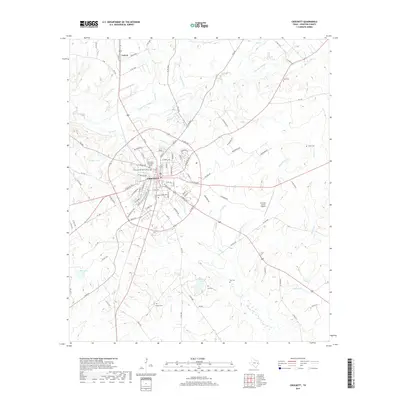
2019 Map of Crockett
USGS Topo · Published 2019About this map
Crockett, the seat of Houston County, is depicted here as a dense intersection of local commerce and residential development. The city’s street grid is tightly structured, with notable landmarks including the Glenwood Cem North Sector and Glenwood Cem South Sector bordering the town center. To the north, the smaller settlement of Latexo sits along the highway, while the eastern landscape is punctuated by the Houston County Airport. The terrain is defined by a dendritic drainage pattern of creeks and bayous, notably Hurricane Bayou and Spring Creek, which navigate the low-lying elevations of East Texas. Rural family heritage is preserved through numerous dispersed burial grounds such as Rice Cemetery, Smith Cemetery, and Hunley Cemetery, indicating long-standing land ownership patterns that persist even as modern residential developments like Eastridge Ests appear on the city's periphery.
Find a feature on this map
107 named features on this map. Tap any name to fly to it.
Don’t see what you’re looking for? This feature index may not catch every label — zoom into the map to look around manually.
Map Details
Editions of this 2019 Crockett Map
This is the sole edition of this map. No revisions or reprints were ever made.
Other maps of this area

1950 · Crockett
USGS Topo · 1:24,000

1950 · Crockett NE
USGS Topo · 1:24,000

1951 · Crockett
USGS Topo · 1:24,000

1951 · Grapeland
USGS Topo · 1:24,000

1951 · Berea
USGS Topo · 1:24,000

1951 · Crockett NE
USGS Topo · 1:24,000

1953 · Palestine
USGS Topo · 1:250,000

1957 · Palestine
USGS Topo · 1:250,000

1963 · Lovelady North
USGS Topo · 1:24,000
1963 · Fodice
USGS Topo · 1:24,000