
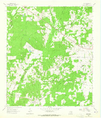
1950 Map of Crockett
USGS Topo · Published 1965About this map
The historic town of Crockett serves as a dense hub of mid-century activity on this survey, where the Missouri Pacific railroad cuts through the landscape. The presence of Mary Allen College and Radio Station KIVY points to the town's role as a regional educational and cultural center during the post-war era. Outside the main settlement, the land is marked by deep historical layers, evidenced by the Old San Antonio Trail and the Old Stagecoach Inn to the northeast.
Find a feature on this map
30 named features on this map. Tap any name to fly to it.
Don’t see what you’re looking for? This feature index may not catch every label — zoom into the map to look around manually.
Map Details
Editions of this 1950 Crockett Map
This is the sole edition of this map. No revisions or reprints were ever made.
Other maps of this area

1950 · Crockett NE
USGS Topo · 1:24,000

1951 · Crockett
USGS Topo · 1:24,000

1951 · Grapeland
USGS Topo · 1:24,000

1951 · Berea
USGS Topo · 1:24,000

1951 · Crockett NE
USGS Topo · 1:24,000

1953 · Palestine
USGS Topo · 1:250,000

1957 · Palestine
USGS Topo · 1:250,000

1963 · Lovelady North
USGS Topo · 1:24,000
1963 · Fodice
USGS Topo · 1:24,000

1964 · Porter Springs
USGS Topo · 1:24,000