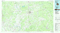
1985 Map of Crockett
USGS Topo · Published 1985About this map
Deep East Texas woodlands and the winding Trinity River dominate this mid-1980s landscape, centered on the hub of Crockett. The map illustrates a rural economy transitioning through the late twentieth century, showing a mix of established agriculture, timber land within the Davy Crockett National Forest, and active extraction at the Oil Field and various Gravel Pits. Significant historical transport routes are visible, most notably the Old San Antonio Road and the Missouri Pacific railroad corridor.
Find a feature on this map
115 named features on this map. Tap any name to fly to it.
Don’t see what you’re looking for? This feature index may not catch every label — zoom into the map to look around manually.
Map Details
Editions of this 1985 Crockett Map
2 editions found
Other maps of this area

1919 · Fairfield
USGS Topo · 1:62,500

1931 · Iola
USGS Topo · 1:62,500

1946 · Alto
USGS Topo · 1:62,500

1950 · Crockett
USGS Topo · 1:24,000

1950 · Crockett NE
USGS Topo · 1:24,000

1950 · Kennard NE
USGS Topo · 1:24,000

1950 · Ratcliff
USGS Topo · 1:24,000

1950 · Centralia
USGS Topo · 1:24,000

1951 · Crockett
USGS Topo · 1:24,000

1951 · Kennard
USGS Topo · 1:24,000