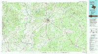
1985 Map of Crockett
USGS Topo · Published 1992About this map
The Davy Crockett National Forest dominates the eastern half of this landscape, a region defined by the winding waters of the Trinity River and the Neches River. The county seat of Crockett serves as a central hub where several highways and the Missouri Pacific railroad lines converge. Local history and genealogy researchers will find numerous rural communities such as Grapeland, Groveton, and Lovelady, along with isolated landmarks like Hazel Chapel and Pearson Chapel.
Find a feature on this map
104 named features on this map. Tap any name to fly to it.
Don’t see what you’re looking for? This feature index may not catch every label — zoom into the map to look around manually.
Map Details
Editions of this 1985 Crockett Map
2 editions found
Other maps of this area

1919 · Fairfield
USGS Topo · 1:62,500

1931 · Iola
USGS Topo · 1:62,500

1946 · Alto
USGS Topo · 1:62,500

1950 · Crockett
USGS Topo · 1:24,000

1950 · Crockett NE
USGS Topo · 1:24,000

1950 · Kennard NE
USGS Topo · 1:24,000

1950 · Ratcliff
USGS Topo · 1:24,000

1950 · Centralia
USGS Topo · 1:24,000

1951 · Crockett
USGS Topo · 1:24,000

1951 · Kennard
USGS Topo · 1:24,000