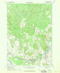
1966 Map of Croghan
USGS Topo · Published 1970About this map
Beaver River power generation and small-town industry characterize this mid-1960s study of Lewis County. The settlement of Beaver Falls stands as a focal point of activity, featuring a Powerplant, the Beaver Falls Airport, and the Beaver River Sch. To the south, the Black River forms the boundary near Denmark, while the Indian River winds through the northern landscape toward Putman Swamp. Local heritage is preserved in numerous burial grounds, including Union Cem near Naumburg and St Stephens Cem further east. The map illustrates the transition from the dense woodlands of the State Forest Preserve, where old routes like Texas Road and Aqueduct lines traverse the terrain, to the more developed river corridors that supported the regional economy through hydroelectric power and local agriculture.
Find a feature on this map
48 named features on this map. Tap any name to fly to it.
Don’t see what you’re looking for? This feature index may not catch every label — zoom into the map to look around manually.
Map Details
Editions of this 1966 Croghan Map
2 editions found
Other maps of this area

1902 · Carthage
USGS Topo · 1:62,500

1904 · Carthage
USGS Topo · 1:62,500

1911 · Antwerp
USGS Topo · 1:62,500

1911 · Lowville
USGS Topo · 1:62,500

1913 · Lowville
USGS Topo · 1:62,500

1913 · Lake Bonaparte
USGS Topo · 1:62,500

1916 · Lake Bonaparte
USGS Topo · 1:62,500

1943 · West Lowville
USGS Topo · 1:31,680

1943 · Carthage
USGS Topo · 1:31,680

1948 · Ogdensburg
USGS Topo · 1:250,000