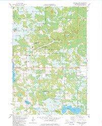
1982 Map of Cromwell East
USGS Topo · Published 1982About this map
The Fond Du Lac State Forest dominates the landscape of Carlton County in this early 1980s survey, illustrating a region defined by extensive wetlands, wildlife management areas, and small rural settlements. The village of Cromwell and the community of Corona are linked by the Burlington Northern railroad, which parallels the main highway corridor across the center of the sheet. Numerous family-named roads, such as Markusen Road, Dahl Road, and Krogh Road, branch out from the town center toward the surrounding timber and marshlands.
Find a feature on this map
30 named features on this map. Tap any name to fly to it.
Don’t see what you’re looking for? This feature index may not catch every label — zoom into the map to look around manually.
Map Details
Editions of this 1982 Cromwell East Map
This is the sole edition of this map. No revisions or reprints were ever made.
Other maps of this area

1953 · Duluth
USGS Topo · 1:250,000

1954 · Sawyer
USGS Topo · 1:24,000

1954 · Martin Lake
USGS Topo · 1:24,000

1956 · Barnum
USGS Topo · 1:62,500

1958 · Duluth
USGS Topo · 1:250,000

1961 · Cromwell
USGS Topo · 1:62,500

1963 · Gowan
USGS Topo · 1:24,000

1963 · Prairie Lake
USGS Topo · 1:24,000

1980 · Duluth
USGS Topo · 1:100,000
1981 · Barnum
USGS Topo · 1:24,000