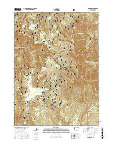
2017 Map of Crook Peak
USGS Topo · Published 2017About this map
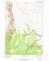
Sherman Valley and the high elevations of the Fremont National Forest define this 2017 landscape in Lake County. The map details a high-altitude drainage network where Honey Cr and its tributaries, including Military Spring and Loveless Cr, carve through the terrain south of Crook Peak. The area is characterized by a sophisticated network of Forest Service roads and recreational routes, including the Southern Oregon Intertie Trail and the Crane Mtn. Natl Rec Trail. This modern survey documents the contemporary management of the timber and recreation lands, showing established clearings like Sage Flat and Bull Prairie. Notable high points like McDowell Peak and Twelvemile Peak dominate the topography, while the N Warner Viewpoint provides a specific vantage over the headwaters of Crooked Cr.
Find a feature on this map
49 named features on this map. Tap any name to fly to it.
Don’t see what you’re looking for? This feature index may not catch every label — zoom into the map to look around manually.
Map Details
Editions of this 2017 Crook Peak Map
This is the sole edition of this map. No revisions or reprints were ever made.
Other maps of this area

1955 · Klamath Falls
USGS Topo · 1:250,000

1958 · Klamath Falls
USGS Topo · 1:250,000

1964 · Lakeview NE
USGS Topo · 1:24,000

1964 · Crooked Creek Valley
USGS Topo · 1:24,000

1964 · Valley Falls
USGS Topo · 1:24,000
1968 · Sage Hen Butte
USGS Topo · 1:24,000

1968 · Crook Peak
USGS Topo · 1:24,000
1968 · Horse Prairie
USGS Topo · 1:24,000
1968 · Drake Peak NE
USGS Topo · 1:24,000
1968 · Little Honey Creek
USGS Topo · 1:24,000