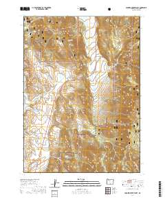
2020 Map of Crooked Creek Valley
USGS Topo · Published 2020About this map
Fremont National Forest dominates the high desert landscape of this portion of Lake County, where managed forest land gives way to the open vistas of the Hart Mountain National Antelope Refuge in the southwest. The geography is defined by the Crooked Creek Valley, a vital corridor for water management in an arid region. The map documents an intricate network of hydraulic features, including the Wilson Ditch and several significant water storage sites such as White Rock Reservoirs, Cory Reservoir, and the tandem Upper Reservoir and Lower Reservoir. These features, alongside isolated water sources like Fawn Spring and Basin Spring, reveal the essential role of water rights and irrigation in sustaining the valley. Transportation is primarily limited to rugged paths like Old Smokey Rd and various county highways, tracing the natural contours of the basin below Fisk Hill.
Find a feature on this map
38 named features on this map. Tap any name to fly to it.
Don’t see what you’re looking for? This feature index may not catch every label — zoom into the map to look around manually.
Map Details
Editions of this 2020 Crooked Creek Valley Map
This is the sole edition of this map. No revisions or reprints were ever made.
Other maps of this area

1955 · Klamath Falls
USGS Topo · 1:250,000

1958 · Klamath Falls
USGS Topo · 1:250,000

1964 · Lakeview NE
USGS Topo · 1:24,000

1964 · Crooked Creek Valley
USGS Topo · 1:24,000

1964 · Valley Falls
USGS Topo · 1:24,000

1964 · Lakeview NW
USGS Topo · 1:24,000

1964 · Clover Flat
USGS Topo · 1:24,000

1964 · Big Baldy
USGS Topo · 1:24,000

1968 · Crook Peak
USGS Topo · 1:24,000
1968 · Horse Prairie
USGS Topo · 1:24,000