
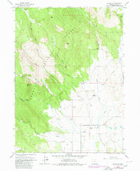
1964 Map of Big Baldy
USGS Topo · Published 1966About this map
Fremont National Forest dominates the western half of this mid-1960s survey, where the high terrain of Big Baldy and Gilmore Peak slopes down toward the cattle country of Lake County. The map documents a classic Oregon high-desert transition, from the timbered heights of Little Baldy to the open ranch lands below. The presence of McDonald Camp (Site) and several active livestock operations like Mendell Ranch, Maxwell Ranch, and Hotchkiss Ranch reflects the enduring agricultural and forestry economy of the region. Water remains the primary resource for these remote operations, evidenced by the scattered Springs and the lush Augur Creek Meadows. A network of unpaved roads and a Jeep Trail provide the only access through this isolated landscape, crossing drainage systems like Thomas Creek and Bauers Creek.
Find a feature on this map
27 named features on this map. Tap any name to fly to it.
Don’t see what you’re looking for? This feature index may not catch every label — zoom into the map to look around manually.
Map Details
Editions of this 1964 Big Baldy Map
2 editions found
Other maps of this area

1955 · Klamath Falls
USGS Topo · 1:250,000

1958 · Klamath Falls
USGS Topo · 1:250,000

1964 · Lakeview NE
USGS Topo · 1:24,000

1964 · Crooked Creek Valley
USGS Topo · 1:24,000

1964 · Valley Falls
USGS Topo · 1:24,000

1964 · Cox Flat
USGS Topo · 1:24,000

1964 · Lakeview NW
USGS Topo · 1:24,000

1964 · Shoestring Butte
USGS Topo · 1:24,000

1964 · Drews Gap
USGS Topo · 1:24,000

1964 · Clover Flat
USGS Topo · 1:24,000