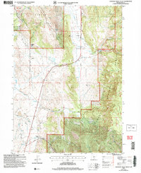
2004 Map of Crooked Creek Valley
USGS Topo · Published 2007About this map
The Fremont National Forest dominates this high-desert landscape in Lake County, where the high-elevation terrain is defined by its seasonal water sources and ranching history. The map highlights a series of established homesteads and legacy locations, including the Kittleson Place (Site) and several family-named outfits like Chambers Ranch and Rehart Ranch. These settlements are linked by the Outback Scenic Byway and the Warner Highway, which cut through the drainage basins of Crooked Creek and Salt Creek. In addition to the agricultural footprint, the land bears the marks of resource extraction with several Prospects and Tarlings noted near Fisk Hill. The southern edge of the quadrangle descends into the dramatic geography of Warner Canyon, providing a transition from the rolling timberland of the forest to the deeper cuts of the canyon floor.
Find a feature on this map
43 named features on this map. Tap any name to fly to it.
Don’t see what you’re looking for? This feature index may not catch every label — zoom into the map to look around manually.
Map Details
Editions of this 2004 Crooked Creek Valley Map
This is the sole edition of this map. No revisions or reprints were ever made.
Other maps of this area

1955 · Klamath Falls
USGS Topo · 1:250,000

1958 · Klamath Falls
USGS Topo · 1:250,000

1964 · Lakeview NE
USGS Topo · 1:24,000

1964 · Crooked Creek Valley
USGS Topo · 1:24,000

1964 · Valley Falls
USGS Topo · 1:24,000

1964 · Lakeview NW
USGS Topo · 1:24,000

1964 · Clover Flat
USGS Topo · 1:24,000

1964 · Big Baldy
USGS Topo · 1:24,000

1968 · Crook Peak
USGS Topo · 1:24,000
1968 · Horse Prairie
USGS Topo · 1:24,000