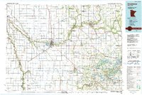
1984 Map of Crookston
USGS Topo · Published 1991About this map
Red Lake River and the Red River of the North define the drainage of this fertile valley landscape, where the confluence of water and rail historically drove development. The regional hub of Crookston is anchored by the University of Minnesota Technical College, while a network of smaller settlements like Fisher, Euclid, and Fertile are connected by the Burlington Northern Railroad and the grid of US Highway 2. This era shows a landscape heavily managed for conservation and water control, evidenced by dozens of judicial ditches such as Judicial Ditch No 62 and numerous protected lands like the Tympanuchus State Wildlife Management Area. The eastern portion of the sheet transitions from agricultural flats toward lake country, featuring Maple Lake and Lake Sarah, which provided recreational value alongside the primary agricultural and transport economy of the Red River Valley.
Find a feature on this map
170 named features on this map. Tap any name to fly to it.
Don’t see what you’re looking for? This feature index may not catch every label — zoom into the map to look around manually.
Map Details
Editions of this 1984 Crookston Map
2 editions found
Other maps of this area

1918 · Kelso
USGS Topo · 1:62,500

1918 · Angus
USGS Topo · 1:62,500

1918 · Hendrum
USGS Topo · 1:62,500

1918 · Twin Valley
USGS Topo · 1:62,500

1918 · Terrebonne
USGS Topo · 1:62,500

1918 · Red Lake Falls
USGS Topo · 1:62,500

1918 · Viking
USGS Topo · 1:62,500

1918 · Warren
USGS Topo · 1:62,500

1919 · Grit
USGS Topo · 1:62,500

1919 · Eldred
USGS Topo · 1:62,500