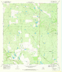
1969 Map of Cross NE
USGS Topo · Published 1971About this map
The Atascosa and McMullen County boundary divides this South Texas landscape, defined in the late 1960s by its extensive network of creeks and man-made watering points. The terrain is dominated by the seasonal drainage systems of Macho Creek, Clear Creek, and La Jarita Creek, which converge as they flow toward the southwest. This area is a classic example of Texas ranching infrastructure, where water management was the primary driver of development.
Find a feature on this map
25 named features on this map. Tap any name to fly to it.
Don’t see what you’re looking for? This feature index may not catch every label — zoom into the map to look around manually.
Map Details
Editions of this 1969 Cross NE Map
2 editions found
Other maps of this area

1925 · Crowther No. 3
USGS Topo · 1:48,000

1930 · Whitsett
USGS Topo · 1:62,500

1942 · Whitsett
USGS Topo · 1:62,500

1953 · Crystal City
USGS Topo · 1:250,000

1955 · Crystal City
USGS Topo · 1:250,000

1956 · Pleasanton
USGS Topo · 1:62,500

1956 · Jourdanton
USGS Topo · 1:62,500

1956 · Franklin Settlement
USGS Topo · 1:62,500

1961 · Crystal City
USGS Topo · 1:250,000
1965 · Caballos Creek
USGS Topo · 1:24,000