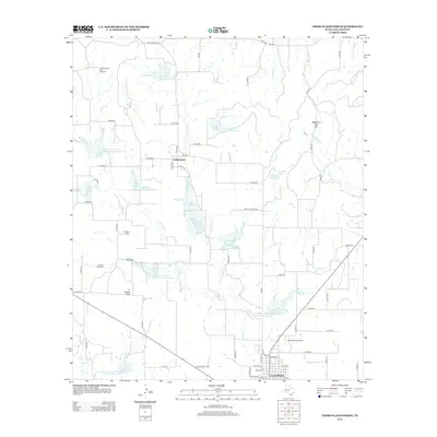
2012 Map of Cross Plains North
USGS Topo · Published 2012About this map
Cottonwood and the northern reaches of Cross Plains anchor this Callahan County landscape, defined by a sophisticated network of water management and rural infrastructure. The area is notable for its series of Soil Conservation Service reservoirs, including Soil Conservation Service Site 8 Reservoir and Site 4 Reservoir, which manage the drainage of Turkey Creek and Cottonwood Creek. These engineered water bodies sit alongside traditional geographic landmarks like the prominent Caddo Peak and the curiously named Mexican Hat Hill near the Sabana River. Local history is preserved at the Oglesby Cemetery and Caddo Peak Cemetery, providing valuable touchpoints for genealogical research. The map also captures modern utility and transport, from the Ross Planes Airport to the Four-Hundred Acre Windmill, illustrating the continued intersection of ranching traditions and contemporary land use in West Central Texas.
Find a feature on this map
70 named features on this map. Tap any name to fly to it.
Don’t see what you’re looking for? This feature index may not catch every label — zoom into the map to look around manually.
Map Details
Editions of this 2012 Cross Plains North Map
This is the sole edition of this map. No revisions or reprints were ever made.
Other maps of this area

1931 · Baird
USGS Topo · 1:125,000

1932 · Baird
USGS Topo · 1:125,000

1954 · Abilene
USGS Topo · 1:250,000

1958 · Abilene
USGS Topo · 1:250,000
1960 · Cross Cut
USGS Topo · 1:24,000
1960 · Webbville
USGS Topo · 1:24,000

1966 · Scranton
USGS Topo · 1:24,000

1966 · Putnam South
USGS Topo · 1:24,000

1966 · Admiral
USGS Topo · 1:24,000
1968 · Rowden
USGS Topo · 1:24,000